Seamlessly tracking land information from the first contact with landowners to property acquisition to long-term stewardship
Background
In 2009, Columbia Land Trust began to look for solutions to tracking a rapidly growing portfolio of conserved land. When it became clear that off-the-shelf databases could not manage the kind of information we needed at our fingertips, we set out to design a database of our own. Many years, and a few versions later, Ouzel (/ˈo͞ozəl/) was born.
The goal was to develop an application that could not only meet our own needs but could be shared with other land trusts experiencing similar data management challenges, as well. To achieve this goal, we have partnered with Tall Oaks Environmental to develop a robust web-based application that helps us do our best work more easily and efficiently.
Subscribers to Ouzel join a collective that will help guide its future development. Our vision is that this database will become a living portal for information that evolves with new technology and is improved through the collaboration and innovation of the conservation community of users.
What Ouzel Does
Ouzel is both a repository of information and an essential planning and reporting tool. Ouzel provides resources for both creating and storing information. It provides key tools for land protection and stewardship work, including spatial data and key document tracking. Ouzel is both flexible and scalable and has the ability to integrate with most contact management databases, as well as other modern tools that support an API.
Ouzel provides:
- A real-time snapshot of key land protection and stewardship information, giving easy access to up-to-date conservation metrics.
- A seamless workflow from our land-acquisition team to our stewardship team, ensuring key information and documents are captured and readily accessible.
- Easy access to all our key documentation, images, and spatial data in one place.
- Access from remote offices, mobile devices, and volunteers via a web-based portal and mobile app.
- Controlled access to staff and volunteers, while protecting sensitive information, thanks to role-based security.
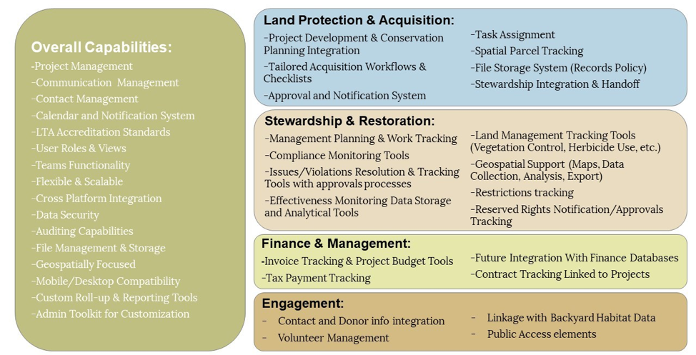
Key functionality of Ouzel includes:
What’s in the Works
Columbia Land Trust and Tall Oaks are in the process of continuing to develop and improve Ouzel’s features, preparing database documentation, and beginning to onboard new Ouzel subscribers. Most of the key functionality has been built in Ouzel, but there is room for improvement. Ouzel will continue to be refined over the coming year, and beyond, with improvements to the user interface, aesthetics, and workflows, as well as with the addition of some planned functionality.
What Does it Cost?
Columbia Land Trust and Tall Oaks will be continuing to refine costs to cover the maintenance of Ouzel while making it accessible to as many land trusts as possible. The current annual subscription fee is $2,500, with no limit on the number of users or number of properties.
There is an additional, one-time fee to set up and onboard a new subscriber. This amount is determined in meetings with the subscriber prior to signing a subscription agreement.
How to Keep in Touch With Progress
To learn more about Ouzel’s functionality, watch one of our recently recorded webinars or attend an upcoming one.
Intro to Ouzel:
Tracking Property Information in Ouzel:
Annual Monitoring with Ouzel:
Tracking Tasks & Work in Ouzel
Upcoming Webinars:
- Date TBD – Working with Spatial Data in Ouzel
- Date TBD – Acquisition Projects in Ouzel
- Date TBD – Property Issues and Violations
- Date TBD – Exploring Data Reports in Ouzel
- Date TBD – Property Monitoring with the Mobile App
To stay connected, fill out this brief survey. The information collected in this survey will help us understand what kinds of organizations are interested in Ouzel and allow us to stay in touch with interested parties. If you have additional questions, would like to schedule a demo, or would like to explore subscribing, contact Natural Area Manager Jennifer Zarnoch.

